 J045434
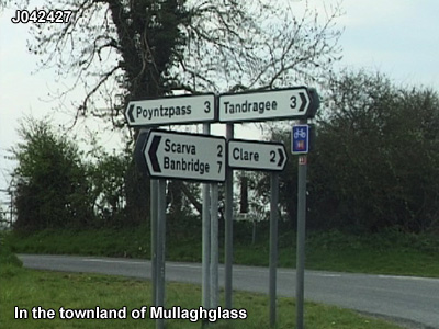
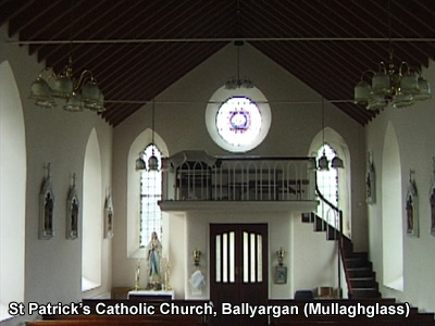
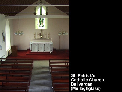
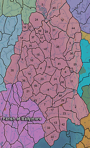
The townland of Mullaghglass is in the parish of Ballymore in Armagh County. It is labelled number 38 on the map.
Paterson (Armachiana, Vol. 16, p.24) notes:
...Mullach signifies the top or summit, and as a root word it forms the beginning of upwards of 400 names.
The Environment and Heritage Service Sites and Monuments Record (2002) notes the following in this townland:
Rath of the Early Christian Period.
SMR NO: ARM 018:003
Irish Grid Reference: J04424280
Townland: MULLAGHGLASS
CONDITION: traces only
A large circular earthwork c.55m in diam. is shown on the OS 6"map of 1 863, but little survives. The N, E & SE sides have been levelled & the interior is occupied by a covered reservoir. Only the SW perimeter has been preserved, by incorporation into a field boundary. The low bank around this part of the monument seems essentially modern, but the external ditch 4m wide x 0.4m deep & c.1 m below the interior may reflect an original feature.
PRONI records: D.2090C 1892 (Rentals, title deeds, maps, etc., of Mullaghglassestate.C 1814); D.1540C 1890 (Title deeds re Mullaghglass estate.C 1730); T.2821/1A, T.2821/3 (Maps of Mullaghglass estate.); D.1540 (Title deeds, etc., re estates in area, Hall family.); D.1540 (Title deeds to estates in area.); D.953 (Correspondence of Wm Whigham re business activities in San Francisco and Tahiti.); D.1152 (Genealogical notes and rent receipts re Browne family.); D.1201/1 (Encumbered estates rental, etc.); D.2090 (Accounts and rentals re Hall estate.); T.2821 (Maps of Hall family property.); D.1670 (Lease of lands.); OS/6/2/22/1 (Surveyed 1835. Engraved 1835.); OS/6/2/22/2 (Surveyed 1835. Engraved 1835. Revised 1861. Engraved 1863.); OS/6/2/22/3 (Surveyed 1835. Revised 1906. Published 1908 (2 copies - 1 reprint 1930 and 1 reprint 1930-1955.).); OS/6/2/22/4 (Surveyed 1906. Revised 1955. Levelled 1889 and 1906. Published 1959 (2 copies).); OS/6/2/26/1 (Surveyed 1834-35. Engraved 1835.); OS/6/2/26/2 (Surveyed 1834-35. Engraved 1834. Revised 1861. Engraved 1863.); OS/6/2/26/3 (Surveyed 1834-35. Revised 1906. Published 1909. Reprinted 1930.); OS/6/2/26/4 (Surveyed 1834-35. Revised 1906. Published 1909. Reprints 1930-1949 with stamped ref 2774.); OS/6/2/14/1 (Surveyed 1834-35. Engraved 1835.); OS/6/2/14/2 (Surveyed 1834. Revised 1860. Engraved 1863 (Stat file copy).); OS/6/2/14/3 (Surveyed 1834-35. Revised 1906. Published 1908. Reprinted 1929. (2 copies).); OS/6/2/14/4 (Surveyed 1834-35. Revised 1906. Levelled 1905-06.Published 1908. Reprint 1951 and 1958.); OS/6/2/14/5 (Surveyed 1834. Revised 1860. Engraved 1863 (Stat file copy). Reprinted 1937 with mss markings in red and stamped ref 2569, 2570.); OS/6/2/14/6 (Surveyed 1906. Revised 1954. Levelled 1892, 1902 and 1904-06. Published 1958 (2 copies).); OS/6/2/18/1 (Surveyed 1835. Engraved 1835.); OS/6/2/18/2 (Surveyed 1835. Engraved 1835. Revised 1860. Engraved 1863.); OS/6/2/18/3 (Surveyed 1835. Revised 1906. Published 1908.); OS/6/2/18/4 (Surveyed 1835. Revised 1906. Published 1908. (2 copies - 1st a reprint 1930, 1933 and 2nd reprint 1933, 1939, 1942, 1946, 1955.); OS/6/2/18/5 (Surveyed 1906. Revised 1954-5. Levelled 1892, 1901-2, 1904 and 1906. Published 1958 (2 copies).); VAL/1B/214, VAL/1B/244A (1st valuation records.); VAL/12B/11/5B, VAL/12B/11/5C, VAL/12B/11/5D, VAL/12B/11/5E, VAL/12B/15/22A, VAL/12B/15/22B, VAL/12B/15/22C, VAL/12B/15/22E, VAL/12B/15/22F (Valuation annual revision list.); VAL/2B/2/32AC 1863 (Griffith valuation list.C 1863); VAL/2B/2/37D (Griffith valuation list.); D/2090 (Hall estate papers.); D.2223/32/27; D.1201/1/9 (Encumbered estates rental.24 Apr. 1856).
J045434