 H998428
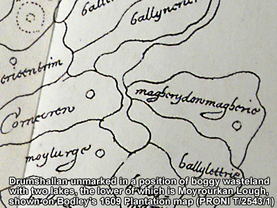
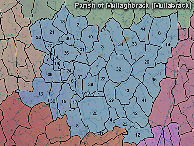
The townland of Moyrourkan is in the parish of Mullaghbrack in Armagh County. It is labelled number 35 on the map.
Paterson (Armachiana, Vol. 16, p.26) notes:
The Environment and Heritage Service Agency Sites and Monuments Record (2002) notes the following in this townland:
Rath from the Early Christian period
SMR NO: ARM 017:002
GRIDREF: H99824251
"Located S of an abandoned settlement, the site has been altered by enclosures & subsequent cultivation. A low, roughly circular platform c.48m N-S x 51 m E-W, raised 0.3-1 m is still visible. The perimeter around the N half is recognisable as a gentle break in slope while field boundaries have preserved a more pronounced scarp to the S. Faint traces of a silted ditch survive on the N but all the other ditches which surround the site seem to be modern."Rath from the Early Christian period
SMR NO: ARM 017:003
GRIDREF: J00364263
"An irregular oval platform, the SE half of which has been raised considerably to create a level interior. The perimeter at this point is marked by a steep scarp falling c.3m which becomes less pronounced towards the N. The N side is protected by a bank c.4m wide & c.2m high above the base of a shallow ditch, also c.4m wide. On the W a low bank is visible, but the ditch has been exaggerated by a farm lane. The site measures 33.5m N-S x 41 m E- W. There is no evidence for an original entrance."Rath from the Early Christian period
SMR NO: ARM 017:005
GRIDREF: H99684187
"Only the N & S sides of this monument have survived intact. On the E the perimeter has been levelled & only a slight terrace can be identified, while part of the W side appears to have fallen away. In spite of this, the dimensions indicate a roughly circular monument 46.5m N-S x 42m E-W. A substantial bank c.1.2 high x c.5m wide is preserved on the N. From the top of the bank a scarp falls to the base of a ditch 4.5m wide x 1.5-2m deep. The bank is lower at the S - 0.5m high. See SM7 file for details."
PRONI records: D.1607/10 (Irish Land Commission sale papers re estate of C.Brinsley Marley.); D.943/2 (Graham estate.); OS/6/2/13/1 (Surveyed 1834-35. Engraved 1835.); OS/6/2/13/2 (Surveyed 1834-35. Revised 1860. Engraved 1863 (Stat file copy).); OS/6/2/13/3 (Surveyed 1834-35. Revised 1905-06. Published 1930.); OS/6/2/13/4 (Surveyed 1905-06. Revised 1954-55. Levelled 1888 and 1892 and 1902, 1905-1906. Levels part revised 1948. Published 1958. (2 copies).); OS/6/2/17/1 (Surveyed 1835. Engraved 1835.); OS/6/2/17/2 (Surveyed 1835. Engraved 1835. Revised 1860. Engraved 1863.); OS/6/2/17/3 (Surveyed 1835. Revised 1906. Published 1908. Reprinted 1929, 1932.); OS/6/2/17/4 (Surveyed 1906. Revised 1954-5. Levelled 1889, 1892 and 1906. Published 1958 (2 copies).); VAL/1B/231 (1st valuation records.); VAL/12B/11/3A, VAL/12B/11/3B, VAL/12B/11/3C, VAL/12B/11/3D, VAL/12B/11/3E (Valuation annual revision list.); VAL/2B/2/29 (Griffith valuation list.).
H998428