 H954367
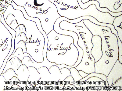
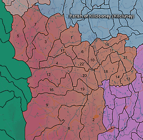
The townland of Kilmachugh is in the parish of Kilclooney in Armagh County. It is labelled number 19 on the map.
The Environment and Heritage Service Sites and Monuments Record (2002) notes the following in this townland:
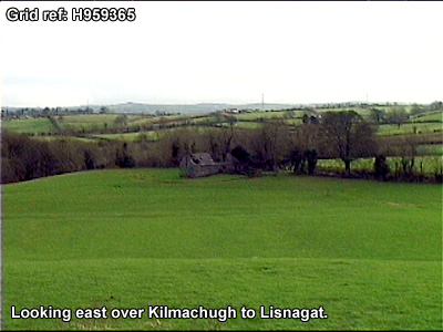
"Blair's Cave", an enclosure of uncertain, possibly Early Christian, period.
SMR NO: ARM 017:039
GRIDREF: H95863663
CONDITION: NO VISIBLE REMAINS
"The 1863 OS 6" map shows a large oval earthwork c.165m NE-SW x 145m NW-SE. The S perimeter was once preserved by a field boundary, but this area is now occupied by bungalows & gardens. The remaining circumference has also been lost & there are no visible remains. The site is bisected by a steep-sided stream valley which forms the townland boundary [between Lisnagat and Kilmachugh]. Paterson refers to "Blair's Cave" on a bank of the river. The entrance was blocked but it is possible that it was a souterrain (the souterrain is in Lisnagat townland - see Arm 017:049). The bridge to N is called Blairs Bridge.
BIBLIOGRAPHY: PATERSON,T.G.F. MS.135 "Rath of the Early Christian Period.
SMR NO: ARM 017:040
GRIDREF: H95403659
CONDITION: SOME REMAINS
"A low, roughly circular platform 35m N-W x 33.5m E-W has survived. The W perimeter has been levelled, and only a faint scarp is visible, while the N, E & W sides have been preserved by incorporation into a curving hedge boundary. Here the scarp is well defined and,on the S, falls c.1 m to the base of a recut ditch 1.5m wide & 0.4m deep. The interior of the site has been heavily cultivated."
PRONI records: D.1644 (Expired leases of earl of Charliemont's estate inarea.); OS/6/2/17/1 (Surveyed 1835. Engraved 1835.); OS/6/2/17/2 (Surveyed 1835. Engraved 1835. Revised 1860. Engraved 1863.); OS/6/2/17/3 (Surveyed 1835. Revised 1906. Published 1908. Reprinted 1929, 1932.); OS/6/2/17/4 (Surveyed 1906. Revised 1954-5. Levelled 1889, 1892 and 1906. Published 1958 (2 copies).); OS/6/2/21/1 (Surveyed 1834-35. Engraved 1835.); OS/6/2/21/2 (Surveyed 1834-35. Engraved 1835. Revised 1860. Revisions engraved 1863.); OS/6/2/21/3 (Surveyed 1834-35. Revised 1906. Published 1908. Reprinted 1921.); OS/6/2/21/4 (Surveyed 1834-35. Revised 1906. Published 1908. (2 copies), Reprints 1934-1957.); OS/6/2/21/5 (Surveyed 1906. Revised 1955. Levelled 1889 and 1906. Published 1958.); OS/6/2/12/1 (Surveyed 1835. Engraved 1835.); OS/6/2/12/2 (Surveyed 1835. Revised 1860. Engraved 1860 (Stat file copy).); OS/6/2/12/3 (Not Received.); OS/6/2/12/4 (Surveyed 1835. Revised 1905-06. Reprinted 1931-1947. Published 1931 with mss markings in red and stamped references 2566, 2567, 2573.); OS/6/2/12/5 (Surveyed 1906. Revised 1948. Levelled 1888 and 1906. Levels revised 1949. Published 1953. (2 copies) - 1 being reprint 1953, 56, 61).); VAL/1B/210A, VAL/1B/210B, VAL/1B/227 (1st valuation records.); VAL/12B/10/13A, VAL/12B/10/13B, VAL/12B/10/13C, VAL/12B/10/13D, VAL/12B/10/25A, VAL/12B/10/25B, VAL/12B/10/25C, VAL/12B/10/25D, VAL/12B/10/25E (Valuation annual revision list.); VAL/2B/2/9A, VAL/2B/2/25 (Griffith valuation list.).
H954367