
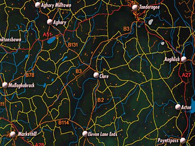
The hamlet of Clare lies on the A27 between Tanderagee and Acton. It is 5.7 km from Markethill. The hamlet is located in the townland of Clare. (See, also, PLACES: TOWNLANDS: CLARE)
In 1838:
"The Presbyterian meeting house of Clare, situated near the western boundary of the parish in the townland of Clare near the road from Armagh and Rich Hill to Banbridge at a distance of 5 and a half miles from Rich Hill, is a slated good house rebuilt in 1828, capable of accommodating nearly 1,000 persons; length 60 feet, breadth 44 feet. Minister the Reverend John Bell, Clare.
The Seceding meeting house, situated near Clare in the townland of Clare on the road from Armagh and Rich Hill to Banbridge at the distance of 5 and a half miles from Rich Hill, is a plain slated rectangular building in good repair, built about 1825; length 50 feet, breadth 27 and a half feet. Minister the Reverend Robert Hawthorn, Tanderagee.
The corn mill, situated at the north east of the Presbyterian meeting house of Clare, is an old 2storey building in bad repair, the property of William Cleland, situated in the townland of Clare on the western bank of the River Cusher. [Nature of wheel, diameter of wheel, fall of water, wooden or metal machinery: no details]."
"There are no natural woods in this parish. It, however, contains about 403 acres of forest trees, of which 95 acres are in Derryallen, 75 in Skigatallagh,16 in Demone, 50 in Brannock, 40 in Clare, 25 in Cargans, 20 in Druminaleg, 14 in Tullyhue, 12 in Moodoge and 12 in Druminure." (Ordnance Survey Memoirs 1835-38)
PRONI records: D.763 (Lease of lands by Lord Fane to Marks family.); D.1253C 1912 (Irish land commission papers for the Dr Salis estate.C 1812); D.3000/127 (Pedigree of family of Rev. John Hadden.); D.1393 (Fane estate papers.); D.763 (Lease of lands by Lord Fane to McLelland family.); D.720 (Map of manor of Clare, estate of Earl of Sandwich[copied in 1806 from earlier survey of 1795].); MIC.1P/329 (Baptisms of Clare Presbyterian Church.); MIC.1P/329 (Marriages of Clare Presbyterian Church.); D.1393/1 (Leases of Fane estate.); T.808/15307 (Petition of Protestant Dissenters, giving list ofnames including those of Clare congregation.); OS/6/2/13/1 (Surveyed 1834-35. Engraved 1835.); OS/6/2/13/2 (Surveyed 1834-35. Revised 1860. Engraved 1863 (Stat file copy).); OS/6/2/13/3 (Surveyed 1834-35. Revised 1905-06. Published 1930.); OS/6/2/13/4 (Surveyed 1905-06. Revised 1954-55. Levelled 1888 and 1892 and 1902, 1905-1906. Levels part revised 1948. Published 1958. (2 copies).); OS/6/2/17/1 (Surveyed 1835. Engraved 1835.); OS/6/2/17/2 (Surveyed 1835. Engraved 1835. Revised 1860. Engraved 1863.); OS/6/2/17/3 (Surveyed 1835. Revised 1906. Published 1908. Reprinted 1929, 1932.); OS/6/2/17/4 (Surveyed 1906. Revised 1954-5. Levelled 1889, 1892 and 1906. Published 1958 (2 copies).); VAL/1B/214 (1st valuation records.); VAL/12B/11/5B, VAL/12B/11/5C, VAL/12B/11/5D, VAL/12B/11/5E (Valuation annual revision list.); VAL/2B/2/32AC 1863 (Griffith valuation list.C 1863).
McKay, P A Dictionary of Ulster Place-names (Belfast, 1999) notes:
On west bank of the Cusher River, 4 kilometres south-west of Tandragee
Parish of Ballymore, Barony of Orior Lower
From the Irish An Clar, perhaps 'The Plankbridge'.
The name may originally have referred to a wooden bridge over the Cusher River.
(Don Chlar, 1645)